

Putting our museum on Google Streetview
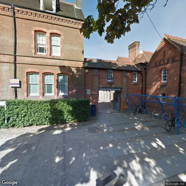
We wanted to put the Museum of English Rural Life
(The MERL) on Google Streetview to make us more accessible to those
with Autism Spectrum Disorder (ASD). For people with ASD it helps to
know what to expect at a place before they arrive, and Google Streetview
remains one of the most popular ways of scoping a place out. (Our offer
for people with ASD is forthcoming at the MERL.)
We thought it would be difficult to get on Streetview. What we didn’t realise is that:
- pretty much anyone with the right equipment can put themselves on Google Streetview
- it isn’t rocket science
So,
in this blog I’m going to tell you how we did it, in case you also want
to do it. If you want to skip straight to our Google Streetview tour, click here.
The background
In case you don’t know, Google Streetview
is attempting to capture every street in 360-degree photography. You
just drag the little yellow guy on Google Maps onto the street and have a
look.
Google Streetview also extends inside buildings, for which you used to have to hire a Trusted Pro to photograph your building. Google now allows anyone to do it themselves, kind of like what crowd-sourcing Panoramio used to be except for 360° photos.
The equipment
Google
will accept any photos taken with decent 360° cameras, and even accepts
photo spheres made with a normal smartphone camera if they’re good
enough. They have a very good page on how to publish for Google Streetview here.
So,
technically you just need a smartphone, but the photo-spheres I’ve made
using just a normal camera almost always come out a bit glitchy. So I
suggest getting a real camera.
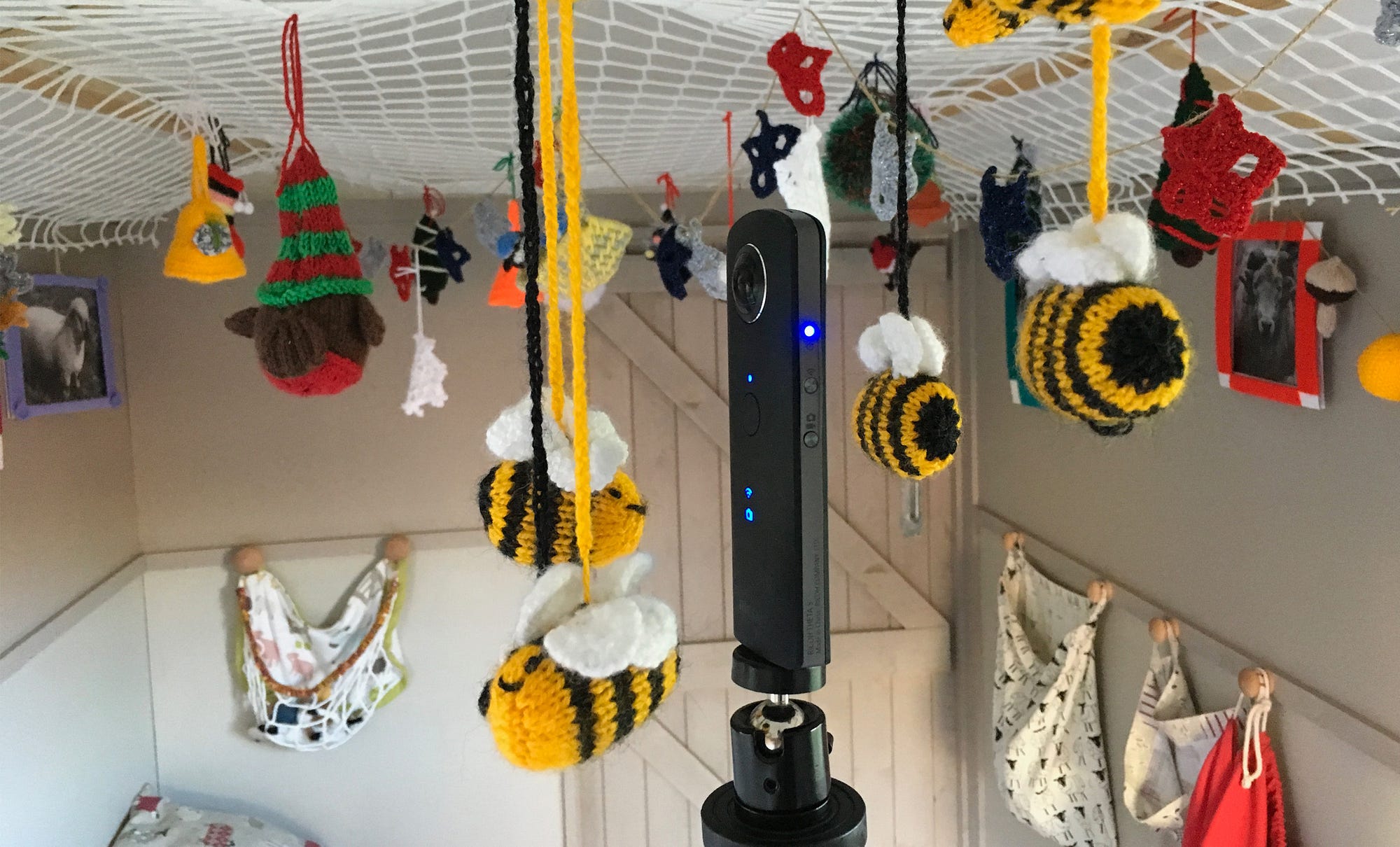
We used a Ricoh Theta-S but we’ve heard good things about the Samsung Gear 360. We could afford to buy our Theta-S thanks to the South East Museum Development Programme Digital Initiatives Fund (thanks guys). Otherwise they cost about £190–300. If you’re a museum near Reading we’d be happy to lend you ours.
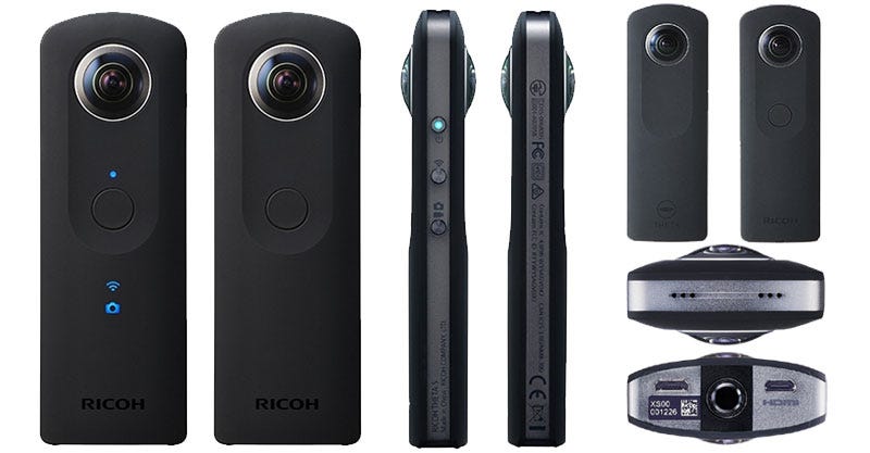
I’m going to talk specifically about the Theta-S.
The basic steps are:
- Install the Theta app (also on Android)
- Connect your smartphone or tablet to the camera’s WiFi
- Take photos remotely using your smartphone/tablet
- Upload them to Google Streetview on their app
- …
- Profit?
The
Theta-S takes images using two cameras on either side of its body, then
stitches them together for you. You just export the jpeg and upload it
onto something like Google Streetview or Facebook – sites which can
translate the file into an interactive photo-sphere.
Setting up the tour
So taking 360° photos is literally as easy as pressing a button, but planning the actual 360° tour? Not so much.
For
starters we didn’t want the photographer in the photo, so we mounted
the Theta S on a monopod and hid behind walls as we took the photo. This only failed once.
We
decided to capture the Museum while it was empty and shot on a Monday,
our closure day. Images of an empty museum, however, may give the wrong
impression of the museum to someone with ASD, as we usually have
visitors milling around. We plan to test this out with focus groups.
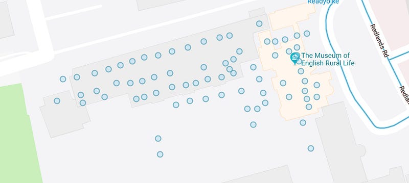
We
also wanted to be able to capture the whole museum, and planning our
tour was made easier by how our galleries are fairly one-way and linear.
Because
we only have our ground floor layer on Google Maps, though, we had to
miss out our first floor open store. We originally had both ground and
first floors published, but rapidly realised it was confusing people as
they kept switching randomly between floors in Streetview. We hope to
see whether getting our ground and first floor plans published on Google means we can then separate Streetview tours between them.
Taking photos
Google
suggests taking photos a metre apart indoors, but we rarely kept to
this. On our first run we had a distance of something like five metres,
and then we went back to fill in some gaps.
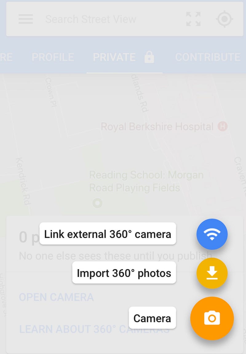
There’s
an option to connect the Google Streetview app to your 360° camera, but
we chose to take the photos and upload them separately (Import 360°
photos). I highly suggest taking all the photos you need, cut any
mistakes and then upload them all in one batch. If you have a museum the
size of the MERL you can do the whole museum in one go (76 photos), or
if you’re larger you could do it by gallery.
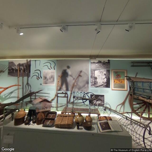
After
taking our photos we also realised some of them featured copyrighted
artworks. We opened these images in Photoshop, blurred out the artworks
and re-saved them – they still worked fine after editing, which was a
relief. The Google Streetview app also gives you the option of
automatically blurring faces.
Publishing
Once you have your photos collected you need to select all your photos and attach them to an address (i.e., your museum).
With
all the photos still selected, you then need to choose their precise
locations on Google Maps. This step is probably the most time-consuming.
As well as placing them in the exact spot you took them on your
floorplan, you also need to orient them to the compass so they’re
pointed in the right direction. This is very important for when you
connect your photos in a tour.
When
your photos are placed and oriented you can publish them to Google
Streetview. They usually show up fairly fast on the app and on desktop.
Connecting photos
The
beauty of Streetview is that you can place your photos in a sequential
tour. The option to link photos is only available after publication.
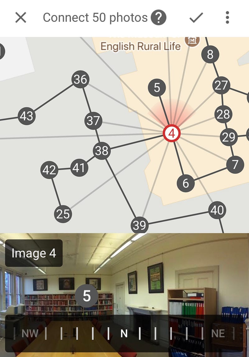
To do this I’d again suggest selecting all your photos at once, and then choosing the option to place and link.
You connect your photos by simply tapping the line between them, and you can link more than one picture to another.
That’s it.
It
updates instantly on the app, but it takes a couple of days before you
will be able to navigate through your photos on desktop using your
keyboard’s arrow keys or on your phone by tapping around.
Conclusions
The
aim of publishing our museum on Google Streetview is to prepare people
for what to expect at the Museum. It definitely accomplishes that.
We
considered photos and video, and have these options available too, but
nothing beats Streetview for giving the full picture. People already use
Google and Streetview, and it meant we could also embed the tour on our
website.
With
our planning, testing and re-runs the whole process probably took us
three full days of work. If you know what you need to capture, organise a
day for photography and dedicate the day to editing the photos then you
could easily get a museum the size of the MERL done in a day’s work.
A note on the Google Streetview app
I
don’t know whether it’s because I installed it on an iPad, but the
Google Streetview app is buggy as hell. It crashes, it is unresponsive
and often the map is completely obscured by cards. Prepare to be
frustrated, and work/save in batches to avoid losing your work.
Another
weird glitch which hasn’t been fixed yet is the option to transfer the
rights of your photos to the place where you took them. This is
primarily intended for Trusted Pros who are hired to make 360-degree
tours, and who then transfer the rights to the people who commissioned
the tour. It seemed strange that we could transfer rights to photos
taken using the MERL Google account to our same Google account tied to
the business. We did it anyway and all of our photos promptly
disappeared from Google Maps.
So, don’t do that until they’ve fixed it? But otherwise have fun.